Remote Sensing and Archaeology in the Maya Lowlands

Past Work
Since the beginning of investigations, archaeological survey within the Maya Lowlands has long been hindered by thick vegetation, relentless insects, and a pronounced rainy season. The wider perspective necessary for an understanding of a site area is not often easily obtained within the Maya Lowlands.
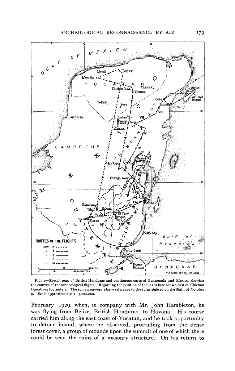
One of the first ways in which Maya archaeologists utilized remote sensing to gain a greater perspective was through an unlikely ally. Charles Lindbergh, on his way back from establishing an air mail route to Panama in 1929, noticed the tops of Maya structures sticking through the vegetation in the Yucatan Peninsula and reported his finding back to Alfred V. Kidder of the Carnegie Institiute. Kidder was conducting excavations in New Mexico at the time and invited Lindbergh to his camp to test the idea of aerial archaeological reconnaissance. The two were so impressed with the results that plans for investigations within the Yucatan were immediately put together. Pan-American Airlines agreed to loan one of their aircraft to Lindbergh, and the men drew up plans that involved flights over portions of present-day Guatemala, Belize, and Mexico.


In October of 1929, Kidder, Lindbergh, and Oliver Ricketson Jr. (another archaeologist) began aerial investigations of the Maya Lowlands. Flying at approximately 500 feet and at a speed of 75-80 miles per hour, Lindbergh and Kidder flew around major Maya lowland centers like Tikal and Uaxactun. The trip proved extremely successful, with many pictures taken of famous sights from new and extremely informative angles. Kidder specifically noted the importance in aerial survey when it came to understanding the extent of a site and its relative location to geographic features. Although difficult to obtain extremely accurate measurements, this initial survey proved the usefulness of aerial survey to archaeology in the Maya Lowlands.
Sikorsky amphibion used by Lindbergh, Ricketson and Kidder, 1930
Charles Lindbergh's investigations of the Yucatan laid the foundation for aerial survey within the Maya Lowlands
A sketch map of the flights paths in 1929, Ricketson and Kidder, 1930
The Maya center of Tikal in Guatemala, as photographed by Alfred Kidder, Ricketson and Kidder 1930

Chichen Itza, Mexico, Ricketson and Kidder, 1930
Source: An Archeological Reconnaissance by Air in Central AmericaOliver Ricketson, Jr. and A. V. KidderGeographical Review , Vol. 20, No. 2 (Apr., 1930), pp. 177-206Published by: American Geographical SocietyArticle
Dr. Thomas Sever and NASA

Dr. Thomas Sever, Space Archaeologist, University of Alabama, Huntsville
Dr. Thomas Sever pioneered the use of satellite imagery in archaeological reconnaissance. Inspired by the work of Lindbergh and Kidder in 1929, Dr. Sever recognized the potential that satellite imagery had in revolutionizing how archaeological survey is conducted. Starting in the 1980's, Dr. Sever began to look at data from the Landsat Thematic Mapper, Thermal Infrared Multispectral Scanner (TIMS), and airborne color infrared (CIR) photography.
Dr. Sever began his investigations with the intention of finding a spectral signature within these datasets that was specific to archaeological remains. Dr. Sever and his collegues attempted a variety of supervised and unsupervised classification techniques, but were unable to obtain conclusive results. Investigations were hindered by the low spatial resolution of the data (30 meter pixel size). However, the process was established as another means of time-effective archaeological reconnaissance. (Saturno, Sever, Irwin, Howell, and Garrison, Putting Us on the Map: Remote Sensing Investigation of the Ancient Maya Landscape; 2006)
Though unsuccessful in his initial attempts, Dr. Sever eventually established a basis of the use of satellite data in locating archaeological ruins. His accomplishments include:
-Mapping prehistoric roads in Chaco Canyon, New Mexico in 1982 with the use of NASA's Thermal Infrared Multispectral Scanner (TIMS)

Color infrared photograph showing location of ancient roadway, Costa Rica, http://weather.msfc.nasa.gov/archeology/arenal.html
In 2000, Dr. Sever aided archaeologists of the Western Belize Regional Cave Project in utilizing Landsat 5, 7, and IKONOS imagery in locating caves. Caves are important archaeologically in that they are frequently associated with Maya occupation and have a greater chance of preservation.
The archaeologists used thermal bands to isolate the relatively constant 60 degree farenheit temperature found within most caves in the Belize region. The surrounding area fluctuates widely in temperature and reaches heights of around 100 degrees farenheit. Thermal imagery helped the researchers to locate cave openings, which aided in the location of excavation units. http://archive.archaeology.org/online/features/belize/remote.html

Landsat 7 image, thermal band, http://archive.archaeology.org/online/features/belize/remote.html